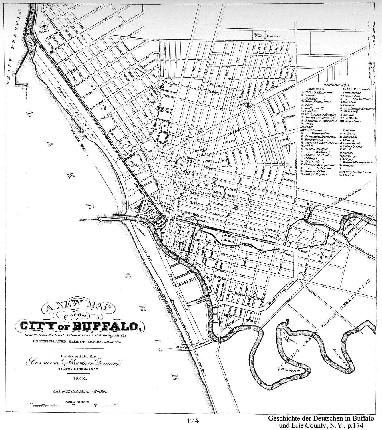
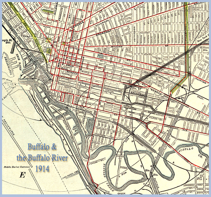
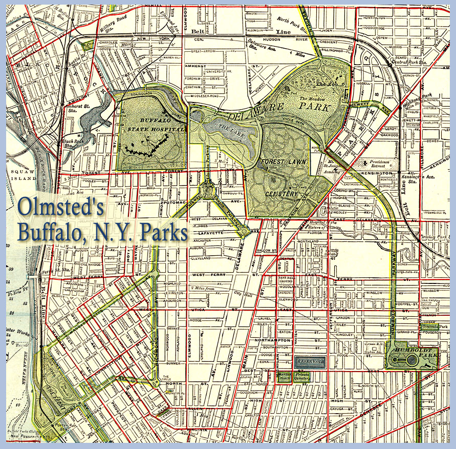
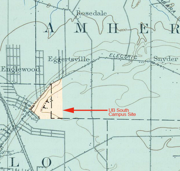
Buffalo and Western New York in Maps: UB Collection
UB Libraries Map Collection
Searching the UB Libraries Map Collection
The UB Map Collection has maps, charts, aerial and satellite photos, and online maps of Western New York, including Erie, Niagara, and other local counties. These maps are in a variety of scales and describe many different aspects of the city and the region.
Most of these maps are located either under a Library of Congress call number, or under the U.S. Government, Superintendent of Documents (SuDocs) numbering system. All of these maps may be located using the Libraries' Catalog, and then retrieving the desired map from the map drawer.
Search Tip: When searching the Libraries' Catalog you may find listings using the following search tip: Enter a subject search, beginning with erie county n y--maps. The following is an example:
s = erie county n y--maps
This will locate almost all Erie County maps. To locate topographic maps of Buffalo, enter the following:
s = buffalo n y--maps topographic
Among this collection are what are referred to as historical topographic maps. These are older topographic maps (1895-1950) of New York State that are kept in the Map Collection Reference Room. Searching the Libraries' Catalog is the same as for regular topographic maps.
You may also perform an advanced search using the "Maps" format to limit your search to only maps and atlases.
What's "in the back"?
While most maps in the open floor of the Map Collection may be checked out and removed from the library, we do have a small collection of rare and fragile local maps and atlases in the locked map office. Please contact the Map Librarian for assistance with this collection, which includes the Sanborn atlases (see below), aerial photographs and local sheet maps.
We are in the process of inventorying our county and regional atlases located in the map office, and will be updating the below table with additional information to help researchers identify potentially useful maps in our locked area.
Geographical Scope |
Title |
Year |
Notes |
| Erie County | New Topographical Atlas of Erie Co. New York | 1866 | Reprint of the 1866 ed. published by Stone & Stewart, Philadelphia "This book is no. 288 of 300 copies; number 5 of a series." |
| Chatauqua County | New Topographical Atlas of Chatauqua County New York | 1867 | |
| Allegany County | Atlas of Allegany County New York | 1869 | 1971 reprint of 1869 original… "This book is no. 216 of 300 copies; number 11 of a series." |
| Cattaraugus County | Atlas of Cattaraugus County New York | 1869 | 1971 Reprint of the 1869 original "This book is no. 135 of 300 copies." |
| Chenago County | Atlas of Chenago County New York | 1875 | 1971 Reprint of the 1869 original "This book is no. 135 of 300 copies." |
| Niagara and Orleans Counties | Atlas of Niagara and Orleans Counties New York | 1875 | 1971 Reprint. Originally published: Philadelphia : Beers, Upton & Co., 1975 |
| Buffalo | Atlas of the City of Buffalo New York | 1884 | |
| Greater Buffalo and Niagara region | Atlas of the Vicinities of the Cities of Niagara Falls, North Tonawanda, and Buffalo, New York | 1893 | GM Hopkins, publisher |
| Buffalo | Atlas of the City of Buffalo New York | 1894 | |
| Wyoming County | New Century Atlas Wyoming County, New York: With Farm Records | 1902 | |
| Genesee County | The New Century Atlas of Genesee County, New York: With Farm Records | 1904 | |
| Erie County | New Century Atlas Erie County New York | 1909 | |
| Orleans County | New Century Atlas of Orleans County, New York | 1913 | |
| Erie County | Atlas: Erie County | ca. 1939 | Prepared by Niagara Frontier Planning Board |
Soil Surveys
UB Libraries has print copies of soil surveys for Erie County.
- Soil survey of Erie County, New York / United States Department of Agriculture, Soil Conservation Service ; in cooperation with the Cornell University Agricultural Experiment Station. [Washington, D.C.?] : The Service, 1986. These soil surveys are available in print in the following UB locations:
- Lockwood Library General Collection / S591 .A22 N.Y. Erie
- Lockwood Library Science & Engineering Reference Collection / S591 .A22 N.Y. Erie
- Libraries Annex: US A 57.38: Er 4
- Abbott Library Architecture & Planning / General Book Collection: S599.N7 S55 1986
- Abbott Library Architecture & Planning / Course Reserve: S599.N7 S55 1986.